Contact Information

Storm Surge Hazard spatial distribution data set (2018)
Dataset Overview
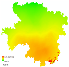
On the basis of the global tropical cyclone track dataset, the global disaster events and losses dataset, the global tide level observation dataset and DEM data, coastline distribution data, land cover information, population and other related data of 34 key nodes, indicators related to the disaster danger of storm surge in each unit are extracted and calculated using handred meters grid as evaluation unit, such as historical intensity of tide level frequency of storm historic arrival, historical loss, distance of offshore line, etc. The comprehensive index of storm surge disaster danger is constructed, and the danger index of storm surge is obtained by using the weighted method. Finally, the storm surge danger index is normalized to 0-1, which can be used to evaluate the danger level of storm surge in each assessment unit. The key nodes data set only contains 11 nodes which have risks.

Dataset Details
Spatial Resolution:
Time Resolution:
Product Number: XDA20030302_037
Create Institution: National Tibetan Plateau/Third Pole Environment Data Center
Created By: DONG Wen
Creation Date: 2021-09-23 00:00:00
File Size: 1
Data Format: GeoTiff
Type Of Data: grid;
Data Label:
