Contact Information

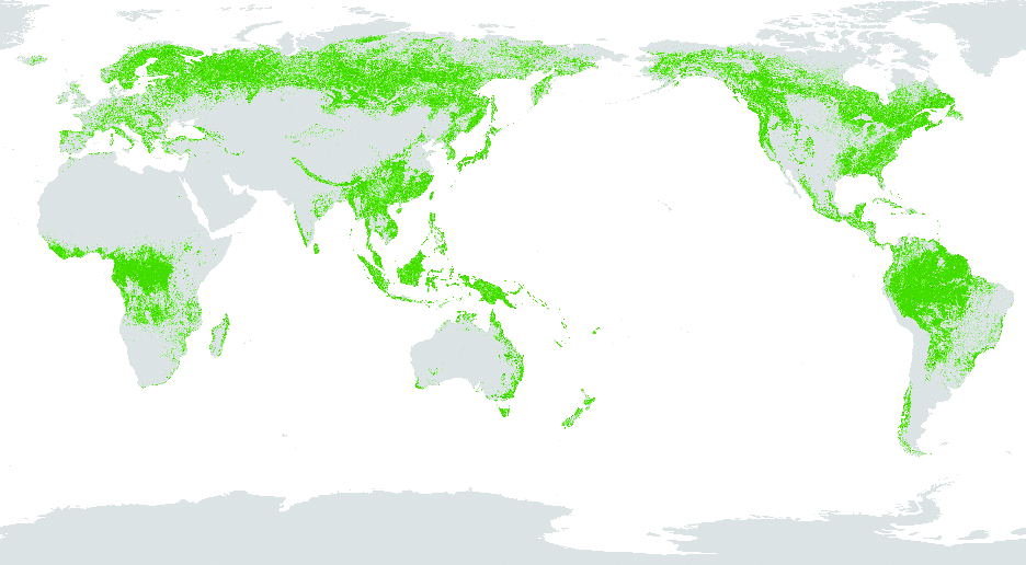
Global 30-m spatial distribution of forest cover in 2020 (GFC30_2020)
Dataset Overview
Based on Landsat series satellites, China GF-1, GF-6 and other satellite images, GFC30_2020 achieved a spatial resolution of 30m, using machine learning algorithms with global ecological geographic partitioning and crowd source sample data. The data source uses the 2020 global forest vegetation growth season images, and when the data quality cannot meet the requirements due to cloud coverage or other reasons, data with similar time will be selected. The overall accuracy of the product is higher than 85%.

Dataset Details
Spatial Resolution: 30m
Time Resolution: 2020
Product Number: XDA19090301_002
Create Institution: International Research Center of Big Data for Sustainable Development Goals
Created By: Xiaomei Zhang; Guojin He; Tengfei Long
Creation Date: 2022-04-25T16:00:00.000Z
File Size: 1010
Data Format: GeoTiff
Type Of Data: grid
Data Label:
Naming Convention
The product was projected in a geographic (Lat/Long) projection at 0.00025o (approximately 30-m resolution), with the WGS84 horizontal datum and the EPSG:4326 vertical datum. The results consist of 504 tiles of 10º×10º, and each tile contains about 40,000×40,000 pixels. The data format is GeoTIFF. Each tile is coded according to the latitude and longitude shown in the upper left corner, with latitude in the front and longitude in the back. Latitude is two digits, with a prefix of N/S; longitude is three digits, with a prefix of E/W, where N is used at 0º latitude, and E is used at 0º longitude. Each tile file contains a layer in which the value of 1 represents forest and the value of 0 represents non-forest area.
Data Citation
Xiaomei Zhang, Guojin He, Tengfei Long, et al. Global 30-m spatial distribution of forest cover in 2020 (GFC30_2020), Beijing: International Research Center of Big Data for Sustainable Development Goals (CBAS), 2022. doi: 10.12237/casearth.625e1760819aec2a46dcd2d8
Data Licence Agreement
Users of this product shall clearly indicate the source as "Global 30-m spatial distribution of forest cover in 2020" in all forms of research output, including, but not limited to, published and unpublished papers, theses, manuscripts, books, reports, data products, and other academic output. The data producers are not responsible for any losses caused by the use of the data. The boundaries and marks used in the maps do not represent any official endorsement by or opinion of the data producers.
