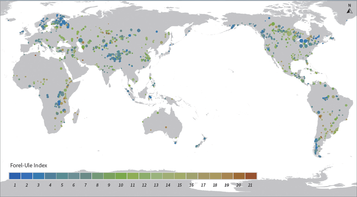
Global 500-m Forel-Ule Index product of large lakes from 2000 to 2021 (FUIGL500_2000-2021)
Dataset Overview

The Forel-Ule Index (FUI), also known as the water color index, can be a useful indicator of overall water quality. It originates from the traditional Forel-Ule scale, which classifies the color of natural water into 21 scales ranging from dark blue to yellowish-brown. In generally, the lower the FUI, the cleaner the water; conversely, the higher the FUI, the more turbid the water. The input data are the Terra MODIS land surface reflectance data. The data was transformed from RGB (red, green, blue) color space to the CIE (Commission Internationale d’Eclairage) color space and finally the FUI was derived.

Dataset Details

Spatial Resolution: 500m

Time Resolution: Annual

Product Number: XDA19090136_002

Create Institution: International Research Center of Big Data for Sustainable Development Goals

Created By: Shenglei Wang; Junsheng Li

Creation Date: 2023-03-22T05:41:16.740Z

File Size: 13132

Data Format: GeoTiff

Type Of Data: grid

Data Label:

Naming Convention

This product uses the WGS84 geographic coordinate system and latitude/longitude projection (EPSG: 4326). The data are stored in GeoTIFF format. Each annual product is divided into spatial tiles, each tile having a spatial extent of 10° ×10° latitude and longitude. Each tile contains one data layer (band) with integers from 1 to 21 for the FUI scales and 0 for the background value.

Paper Citation

Shenglei Wang, Junsheng Li, Wenzhi Zhang, et al. 2021. A dataset of remote-sensed Forel-Ule Index for global inland waters during 2000–2018. Scientific Data, 8, 20. https://doi.org/10.1038/s41597-021-00807-z

Shenglei Wang, Junsheng Li, Bing Zhang, et al. 2018. Trophic state assessment of global inland waters using a MODIS-derived Forel-Ule index. Remote Sensing of Environment, 217, 444-460. https://doi.org/10.1016/j.rse.2018.08.026

Data Citation

Shenglei Wang, Junsheng Li. Global 500-m Forel-Ule Index product of large lakes from 2000 to 2021 (FUIGL500_2000-2021), Beijing: International Research Center of Big Data for Sustainable Development Goals (CBAS), 2023. doi: 10.12237/casearth.640f00a8819aec3f2b52a492

Data Licence Agreement

Users of this data product shall clearly indicate the source and the authors of "Global 500-m Forel-Ule Index product of large lakes from 2000 to 2021" in all forms of their research output (including, but not limited to, published and unpublished papers/reports, theses, monographs, data products, and other academic output) generated by using this data product, and shall cite the corresponding references. The data producers shall not be liable for any loss arising from the use of this data product. The boundaries and masks used in the maps do not represent an official opinion or endorsement by the data producers.