Contact Information

Global daily 1-km actual evapotranspiration from 2000 to 2021 (ETMonitor-1km_2000-2021)
Dataset Overview
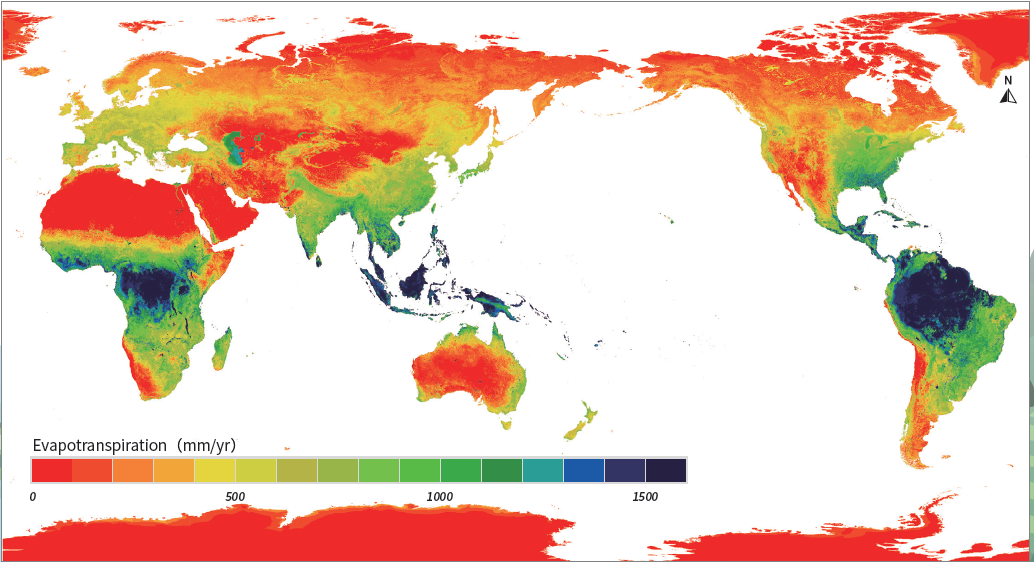
The evapotranspiration (ET) in this product refers to the actual land surface evapotranspiration, which is the sum of vegetation transpiration, canopy rainfall interception loss, soil evaporation, open water evaporation, and ice/snow sublimation. ET is an essential ecohydrological process that links the energy, water and carbon cycles of the land surface and plays a critical role in the Earth system. Accurate estimation of land surface ET is not only of great significance for the study of the water cycle and energy exchange processes of the Earth system, but is also valuable for applications in the effective management of water and land resources, monitoring of crop water requirements for irrigation scheduling, flood/drought monitoring and assessment for disaster management, and many others. This data product was generated using the ETMonitor model in combination with multi-source remote sensing data and reanalysis data. The ETMonitor model established a multi-parameterization scheme to estimate the evapotranspiration components (vegetation transpiration, canopy rainfall interception loss, soil evaporation, water surface evaporation, snow and ice sublimation), taking into account the simulation of the energy balance, water balance and plant physiological processes that control the surface energy and water exchanges. All the ET components of each remote sensing pixel were first estimated, and the total actual ET of each pixel was obtained by accumulating the ET components. The validation was conducted using flux observations from the 251 ground flux sites around the world, covering a wide range of terrestrial ecosystems as well as water and snow/ice surfaces. The validation result showed that the Root Mean Square Error of daily evapotranspiration of this product generated by the ETMonitor model was 0.93mm/day. The unit of the evapotranspiration in this product is mm/day, with a conversion factor of 0.01.

Dataset Details
Spatial Resolution: 1000m
Time Resolution: Daily
Product Number: XDA19030203_006
Create Institution: International Research Center of Big Data for Sustainable Development Goals
Created By: Chaolei Zheng, Li Jia, Guangcheng Hu
Creation Date: 2023-03-22T05:41:16.751Z
File Size: 22
Data Format: GeoTiff
Type Of Data: grid
Data Label:
Naming Convention
Paper Citation
Data Citation
