Contact Information

GLC_FCS30D: global 30-m land-cover dynamic monitoring product with a fine classification system from 1985 to 2022
Dataset Overview
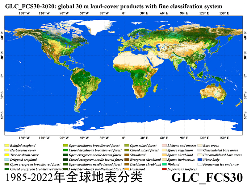
GLC_FCS30D is the first global fine land cover dynamic product at a 30-meter resolution that adopts continuous change detection. It utilizes a refined classification system containing 35 land categories and covers the time span from 1985 to 2022. Before the year 2000, the update cycle was every 5 years, while after 2000, it is updated annually. Zhang, X., Liu, L., Chen, X., Gao, Y., Xie, S., Mi, J., 2021. GLC_FCS30: global land-cover product with fine classification system at 30 m using time-series Landsat imagery. Earth Syst. Sci. Data 13, 2753-2776 , https://doi.org/10.5194/essd-13-2753-2021. Zhang, X., Liu, L., Zhao, T., Chen, X., Lin, S., Wang, J., Mi, J., and Liu, W.: GWL_FCS30: a global 30 m wetland map with a fine classification system using multi-sourced and time-series remote sensing imagery in 2020, Earth Syst. Sci. Data, 15, 265–293, https://doi.org/10.5194/essd-15-265-2023, 2023. Zhang, X., Liu, L., Zhao, T., Gao, Y., Chen, X., and Mi, J.: GISD30: global 30 m impervious-surface dynamic dataset from 1985 to 2020 using time-series Landsat imagery on the Google Earth Engine platform, Earth Syst. Sci. Data, 14, 1831–1856, https://doi.org/10.5194/essd-14-1831-2022, 2022.
ftpsever:obsftp.cstcloud.cn
user:p4-xda19090125-011
password:a31c7a0d09

Dataset Details
Spatial Resolution: 30m
Time Resolution: In 1985-2000, 5 year-periods, and in 2000-2022, annual update
Product Number: XDA19090125_011
Create Institution: International Research Center of Big Data for Sustainable Development Goals
Created By: Liangyun Liu
Creation Date: 2023-10-09T07:40:13.530Z
File Size: 1923
Data Format: GeoTiff
Type Of Data: grid
Data Label:
