BIG DATA for SDGs

BIG DATA for SDGs

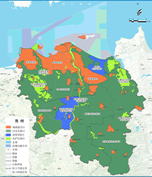
Remote sensing monitoring expanded in urban areas of Hainan Island for 33 years
Drawing on the core ideas of the United Nations' 2030 plan for sustainable city and community building.Remote sensing image data, statistical data and planning materials were used to study the towns of 18 major cities and counties in Hainan Island.The expansion process involves mapping and analysis to construct over 30 years since Hainan Island was established as a province in 1988.The changes in the built-up area of towns systematically reflect the expansion characteristics of urban construction land.